Finmeccanica: technologies for the landscape’s safeguard
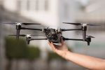
Finmeccanica, global player in the high technologies for aerospace, defence and security, produces leading-edge monitoring solutions for a sustainable development. Such solutions include both remote sensing and earth observation systems and the platforms using them, from satellites to aircraft and drones, up to data processing and to installation of control centres to plan interventions.
In particular, remote sensing allows, through the use of non-invasive technologies such as radar interferometry, to detect ground deformations over wide area with millimetric precision, while hyperspectral imaging allows the acquisition of the ‘spectral signature’ of materials observed at a distance to identify their exact composition, and to acquire information to study the landscape.
The Remote Sensing Special Plan, promoted by the Italian Ministry of the Environment and Protection of Land and Sea, is the first example of application of the interferometric technique on a national scale for the monitoring of the areas under hydrogeological instability risk, through COSMO-SkyMed satellites, where the best competencies of Telespazio, Selex ES and Thales Alenia Space are concentrated.
Instead, hyperspectral cameras are used within the national research project SMAT - Sistema di Monitoraggio Avanzato del Territorio (Advanced Land Observation System) - for the development of technologies for the prevention and control of natural disasters such as floods, fires or landslides. The project represents the first example of use of the Finmeccanica Falco and Sky-Y drones for environmental applications.
Coasts’ erosion level and pollution level monitoring to support emergency management, improvement and precision farming are other interesting areas of application for remote sensing, for which Finmeccanica has available leading-edge solutions, already used in France in order to optimise vineyards’ productivity and quality. It is in fact possible, through the mapping of the agricultural areas achieved thanks to the satellite and hyperspectral data, to support agronomic interventions aimed at production optimisation and land safeguard. Finally, the interest is continuously increasing for tests and projects integrating data and images acquired with satellites and drones, equipped with sensors that allow monitoring and diagnosing the conservation state of monuments and archaeological sites, supporting the effective and timely planning of maintenance or recovery interventions.
Комментарии